US FISH AND WILDLIFE SERVICE ANNOUNCES GRANTS TO CONSERVE WETLANDS 2/5/16 Sand and gravel
US Fish and Wildlife Service Director Dan Ashe has announced that over US$20 million will be provided to 28 projects in 12 coastal states to protect, restore or enhance more than 10,000 acres of coastal wetlands and adjacent upland habitats under the National Coastal Wetlands Conservation Grant Programe.
State and local governments, private landowners, conservation groups and other partners will contribute over US$20 million in additional funds to these projects, which acquire, restore or enhance coastal wetlands and adjacent uplands to provide long-term conservation benefits to fish and wildlife and their habitats.
“The Fish and Wildlife Service’s Coastal Wetlands Grants provide critical funding in the effort to protect some of our most fragile and at-risk wildlife habitats, said Service Director Dan Ashe. “With rising ocean levels eating away at coastal wetlands from one side and development claiming more and more acres on the other, our coastal wetlands are being squeezed into an ever thinner sliver of land. Never before has it been so important to protect these places.”
The programme, funded in part through taxes paid on equipment and fuel purchases by recreational anglers and boaters, creates significant benefits for other recreationists and the American public. The billions of dollars generated through recreational angling, boating, waterfowl hunting and bird watching benefit communities in the vicinity of wetlands restoration projects.
States and territories receiving funds are California, Georgia, Maine, Maryland, Michigan, New Hampshire, New Jersey, North Carolina, Oregon, South Carolina, Virginia and Washington. Click here for the complete list of projects funded by the 2016 grant programme.
Wetlands in coastal watersheds in the US are experiencing a net annual loss of more than 80,000 acres according to a 2013 report by the service, highlighting the importance of coastal wetland conservation. Conservation of these habitats will not only benefit coastal wetland-dependent wildlife, but will also enhance flood protection and water quality, and provide economic and recreational benefits to anglers, boaters, hunters and wildlife watchers.
“These grants will help coastal communities create on-the-ground projects to make them more resilient and ensure the preservation of our wildlife heritage for future generations,” added Ashe.
Endangered species killed in Savannah Harbor 2/8/16 Sand and Gravel
COLUMBIA, SC
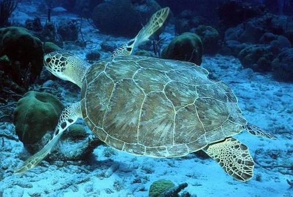
In the past six weeks, five federally protected marine animals have been killed at Savannah Harbor as work crews dredge the shipping channel to maintain and deepen Georgia’s biggest port.
A green sea turtle, two Atlantic sturgeon and a loggerhead sea turtle have died during dredging work since Jan. 1, while a leatherback sea turtle was killed under unknown circumstances, say officials with the National Marine Fisheries Service.
At this point, federal agencies aren’t overly concerned about the deaths because they say some animals — even rare ones — are expected to be killed during dredging projects, such as the $706 million port deepening underway this winter.
But if too many federally protected species die as a result of dredging, it could affect how port deepening and maintenance are conducted in the future.
Should it become apparent the U.S. Army Corps of Engineers will exceed the number of animals legally allowed to be killed during dredging, the fisheries service could require tighter controls on the dredging operations at Savannah, the fisheries service said last week.
That could range from a different dredging schedule to a temporary shut down of the work so officials can seek better ways to protect endangered species. Such measures likely would occur in extreme circumstances, federal officials said.
“If they had more takes than we anticipated, we would have a conversation, basically, on why we think that was happening,’’ said David Bernhart, a marine fisheries service protected resources administrator. “Are there any additional measures that would avoid this?’’
Savannah, like Charleston, is racing to deepen its harbor to accommodate larger ships.
The Corps’ port dredging project in Savannah finally began in the fall after more than 15 years of battles over the environmental impact the work would have on the harbor and on the Savannah River. The dredging will deepen the shipping channel from 42 to 47 feet. Charleston has had issues, as well, although dredging there has not produced the bitter fights that preceded the launch of the Savannah project.
Having a deeper channel for bigger ships is expected to keep both ports competitive — but the Savannah and Charleston dredging projects have an array of environmental rules that must be followed, including protection for endangered or threatened species such as sea turtles, fish and whales.
That includes limits on the number of animals that can be killed.
The Savannah port deepening work, for instance, allows dredges to “take,’’ or kill no more than four Atlantic sturgeon during the harbor deepening project over three winters. That leaves room to kill only two more Atlantic sturgeon during the dredging project over its three-winter schedule. The two sturgeon that died Jan. 26 were discovered by an independent contractor assigned to the dredge, according to the Corps of Engineers.
Atlantic sturgeon are among the most recent additions to the federal Endangered Species Act list. In 2012, the federal government declared Atlantic sturgeon as endangered and in need of protection because populations are declining. A large, prehistoric-looking fish covered in bony plates, the Atlantic sturgeon can grow to 16 feet. Their numbers have dwindled because of overfishing and habitat loss.
Dredges in Savannah also aren’t allowed to kill more than three green sea turtles while the work continues over three winters. That leaves only two more green turtles that can be killed during the harbor deepening work.
Green sea turtles are large reptiles that can grow to 4 feet long and weigh up to 440 pounds, according to the U.S. Fish and Wildlife Service. The federal government listed them under the Endangered Species Act in 1978 as the loss of nesting habitat, entanglement in fishing nets and other factors took their toll on the sea reptiles. Their populations have rebounded in recent years and federal officials are considering loosening some restrictions. Still, green sea turtles remain protected and are not common in Georgia or South Carolina during the winter.
The marine fisheries service “is always concerned about the loss of (endangered or threatened) species, but we recognize that sometimes losses are unavoidable due to the type of action being performed,’’ service spokeswoman Kim Amendola said, noting that “the use of hopper dredges as a part of the Savannah Harbor deepening is essential to completing the work safely in a reasonable time frame.’’
Deaths ‘alarming’Jaclyn Lopez, an endangered species lawyer with the Center for Biological Diversity, called the deaths of five rare animals in six weeks “alarming.’’ While the fisheries service doesn’t think the deaths will hurt overall efforts to replenish turtle and sturgeon populations, Lopez said the loss of a single animal shouldn’t be ignored.
“It does seem alarming that you would lose five of these individuals,’’ Lopez said. “We are not talking about pigeons. We are talking about animals that in some cases are very rare and in other cases have been placed on the precipice of extinction because of different combined factors that have mostly humans behind them.’’
When animals are protected under the Endangered Species Act, specific plans often are developed to help species recover from years of population declines.
Corps officials in both Savannah and Charleston said they are committed to following rules to protect rare animals and fish. Sometimes, for instance, that involves measures to frighten sea turtles so they will move out of the path of dredges, said Savannah Corps spokesman Billy Birdwell.
“We can’t see the bottom of the ocean out there,’’ Birdwell said, noting that the Corps doesn’t have cameras to look for turtles in the murky water. But he said “We do what we can to basically scare the turtles away. Sometimes we’ll drag something along in front of the dredge that moves them out of the way, that stirs them up or wakes them up.’’
Glenn Jeffries, a spokeswoman for the Corps in Charleston, said her agency will follow a plan to protect sea turtles when dredging starts at the South Carolina port, a major competitor to Savannah for business. That $521 million project is expected to begin in about two years. Channels would be deepened from 45 to 52 feet.
Fisheries service officials said the green sea turtle and the two sturgeon may have died because they were near the bottom of the harbor and in the path of hopper dredges, considered more dangerous to some marine life than other types of dredges.
As opposed to some dredges, a hopper sucks material from the bottom with the use of machinery that is dragged across the harbor floor, according to the Corps. But the dredges move faster than some marine life that lie in their path — and that can be lethal. From 2000 to 2010, for instance, hopper dredges killed 10 sea turtles in Savannah Harbor’s navigational channel.
As a result, hopper dredging is to occur only from mid-December through March, when sea turtles are less likely to be in the area, the Corps says. Hopper dredging has been in the harbor’s outer channel this winter, the Marine Fisheries Service says.
Still, it’s not common for hopper dredges, the preferred machinery used by Corps contractors, to kill either green sea turtles or sturgeon.
The juvenile green turtle that died Jan. 5 in Savannah is only the second known green sea turtle to have been killed during a dredging operation in the history of the Georgia port, Bernhart said. One was killed four years ago during a maintenance dredging job, records show.
Loggerheads and leatherbacksIn addition to the green sea turtle and two sturgeon that died from the harbor deepening project, a maintenance dredge killed a loggerhead sea turtle Jan. 1, according to the marine fisheries service.
Loggerhead sea turtles, which can grow to three feet long and weigh 250 pounds, are more common on the Georgia and South Carolina coasts than green sea turtles. Loggerheads were listed as threatened in 1978 under the Endangered Species Act. The maintenance dredging operation that killed the loggerhead is not connected to the dredging to deepen the harbor.
Federal officials say they do not think the recent death of a leatherback sea turtle, reported Jan. 11, was related to dredging because the animals are not typically found near the bottom of harbors and in the path of dredges. Officials are unsure what killed the sea turtle, but say it may have been a ship strike. Leatherbacks are the largest of sea turtles, growing to up to 6 feet and weighing as much as a ton. They are known to migrate great distances. They are listed as endangered under the law.
But federal officials think warmer weather is why some sea turtles, particularly cold-intolerant green sea turtles, lingered in the area longer than they normally would have. Water temperatures along the coast remained in the 60s through much of December and early January, according to federal and state data.
On New Year’s Day, for instance, the water temperature reached 67 degrees in Charleston Harbor, according to the S.C. Department of Natural Resources.
With cooler weather recently, water temperatures along the South Carolina-Georgia coast have dropped into the upper 40s and low 50s. That gives hope that green sea turtles have moved back toward Florida while this winter’s dredging continues, state and federal officials said.
Grizzly bears are rebounding in Yellowstone. Should hunting be allowed to keep numbers in check? 3/4/16 LA Times

A decade after federal wildlife officials tried and failed to remove protections for grizzly bears that live in and near Yellowstone National Park, they are trying again, this time declaring that bear recovery efforts have been a “historic success.”
Pointing to estimates that the Yellowstone population has increased from as few as 136 bears in 1975, the year they were listed as threatened, to as many as 700 today, the U.S. Fish and Wildlife Service this week proposed removing federal protections in favor of an oversight plan that would be enforced by state governments — one that would allow hunting bears that roam outside the park.
The agency said the bear’s range in what is known as the Greater Yellowstone Ecosystem, an area that includes parts of Wyoming, Montana and Idaho, had more than doubled during the last four decades. At the same time, it said the number of bears had remained basically the same since 2002. The agency said that stable population was a sign that “the Yellowstone ecosystem is at or near its carrying capacity for the bears.”
Environmental groups had long anticipated the decision, announced Thursday, and they responded much as they did nearly a decade ago, saying the move would put bears at risk. Some suggested they could take the fight to court, just as they did before.
In 2009, two years after the government attempted to remove protections, a federal judge in Montana restored them, saying that new safeguards put in place were not enforceable and that climate change posed risks to one of the bears’ most important foods — seeds from whitebark pine trees that were dying at alarming rates. The 2009 ruling was upheld on appeal in 2011.
On Thursday, Tim Preso, a lawyer with the environmental law firm Earthjustice, which led the earlier challenge, said in an interview that the firm was still reviewing the new plan but that it appeared to raise many of the same questions that existed a decade ago. Among them: whether state governments would truly meet new requirements that they protect the bears and whether the plan adequately considers how climate change is affecting the animals.
Though more than 700 bears are believed to exist now, the plan would hope to keep the population at about 674, which the government said was the average from 2002 to 2014. If the number dropped to 600, “discretionary mortality” — that means hunting — would not be allowed.
Preso noted that although states have agreed to enforce the plan they have not yet passed binding regulations to do so.
“All three states have to do things to do their part, and we don’t yet know what that’s going to look like,” he said. “As of right now, it’s just a framework without the details.”
Preso said one reason the bears have expanded their range is because the whitebark pine continues to decline, forcing animals to travel farther to find food. He said bears are adapting in some cases by eating more meat, whether wild game or livestock. That creates conflicts with hunters and ranchers and often leads to bears being killed by humans, ostensibly in self-defense or by wildlife officials.
If they are delisted, grizzlies inside Yellowstone National Park could not be legally hunted. But they would not have to wander far, perhaps for as little as 15 minutes from where park visitors can see them in the wild, before they enter legal hunting areas.
“I guess there’s going to be a question of how comfortable the American public is with the killing off of more than 100 grizzly bears,” Preso said.
Political leaders in the three-state area have pressed the government to delist the bears, pointing to the 2007 decision as evidence that they recovered long ago.
“Previous efforts to de-list the bear were held hostage by litigation,” Sen. Michael B. Enzi (R-Wyo.) said in a written statement. “This is no way to manage wildlife. As grizzly bear populations increase beyond capacity in Wyoming, so does the danger posed to livestock, property and humans. That is why it is so important that we turn over management of the species to state authorities.”
The Yellowstone area is home to as many as half of the estimated 1,400 to 1,700 grizzlies believed to exist in the Lower 48 states. The proposed delisting would not apply to bear populations in other areas of the West that are under federal protection.
“All other grizzly bears in the Lower 48 states remain listed,” the Fish and Wildlife Service said.
The plan will go through a formal period of public review and could become final later this year.
A Wilmington neighborhood is an island in a sea of petroleum 3/6/16 LA Times
The chemical train didn't come this morning.
So Gerardo Juarez tinkers in his front yard in Wilmington, talking to his neighbors, trimming his nails with a pocket knife. He throws buckets of laundry water on his lawn to keep it lush for his grandchildren's soccer games.
Juarez, 64, lives on a block of small houses painted peach, periwinkle and baby blue, where many of the residents are related, and most are grandparents by now. They harvest nopales and nectarines from their yards. Some watch TV tuned in from roof antennas. Every July 4, they gather in the street to eat and drink and watch the young ones light sparklers and Piccolo Petes.
But this piece of the middle class has always been hitched to a towering caveat at the end of the block.
Upwind and right next door, the Phillips 66 refinery looms over the neighborhood, a skeletal Goliath of pipes, tanks, valves, boilers, stacks, columns and cracking units. It hisses, clanks, fumes and lofts its own clouds into the sky.
While the refinery's flares don't ignite as often as they used to, the great organism exhales in many places. Juarez can see the facility's breath this clear morning. Rising gas and heat create strange blurry spots in the interstitial spaces. High above, steam pours out of stacks nearly 200 feet in the air. But it's an area he cannot see, just over the wall, a little more than a hundred yards away, that he worries about most. For the last couple of years there, about twice a week, trains have pulled up to long, pill-shaped tanks. Juarez can see only the tops of the tanker cars, but soon after they arrive, he hears a high-pressure hiss, and a powerful smell of fertilizer drifts into his neighborhood. The odor makes him dizzy and nauseated, and he rushes inside at the first hint of it.
When he steps back out later, he finds little yellow dots on the black paint of his car. He has to use wax to get rid of them.
He can only imagine what 37 years of breathing this air might one day germinate in his body.
But he has no plans to leave.
::
The neighborhood is an island in a sea of petroleum.
Four short blocks, 59 homes, wedged between the Harbor Freeway and the 424-acre refinery.
In the broader landscape of Wilmington — one of California's most heavily industrialized zones — residents are exposed to all that belches and wafts from recyclers, chemical plants, scrap yards, six oil refineries, hundreds of oil wells, trucks, trains, and cargo ships in the harbor.
In Juarez's nook of west Wilmington, the refinery came long before the houses, a consequential point even today.
The Union Oil Co. of California built the original refinery in 1919 between the Bixby Slough and the port, on a hill rising to the Palos Verdes headlands.
The burgeoning car culture and the oil boom fed each other, and fed suburban growth. Neighborhoods soon were pushing into working oil fields across the region, and next to the refineries around the port and the South Bay. Oil workers bought many of the homes.
Interested in the stories shaping California? Sign up for the free Essential California newsletter >>
The small bungalows next to the Union Oil refinery were built in the World War II era, Juarez's in 1944.
Wilmington's proximity to the commercial docks, union halls, railroads, fish canneries and manufacturers made it a working-class hub, a natural place for immigrants to start in America.
Juarez and his younger brother Gustavo arrived from the ranch lands of Michoacan, Mexico, in 1976. Gerardo got a job fabricating windows in Gardena. Within three years, he, Gustavo and his brother-in-law were shopping together for a home and found a great deal for a 1,000-square-foot bungalow at 1442 F Street. They had saved just enough for the 20% down payment — $13,000 — and moved their three families in. Just one house and a narrow weedy easement lay between them and the refinery. Juarez knew the air was polluted. But at that time, all of Los Angeles lay smothered in brown smog much of the year.
He had other factors to consider.
The street was quiet. The raised freeway, which had sliced through the neighborhood in 1956, kept at bay the chaos that rattled the rest of the town. Gangs didn't bother them. No one tagged their walls or broke into their cars. They liked the nearby school.
Juarez went on to drive a forklift at the Bumble Bee tuna cannery in Santa Fe Springs for 22 years. He bought out Gustavo and his brother-in-law and owned the house himself.
Gustavo moved across the street, and their children grew up riding bikes over the dirt track jumps and berms they'd built in the easement.
This was the California Juarez had hoped to offer his kids.
Not that the family could ignore what was behind the fence. It was an ever-evolving system, with new components popping up all over, old ones going dormant. On normal days, it was loud and smelly, like an enormous lawn mower idling next door.
When a particularly noxious gas came over the fence, the neighbors complained. But nothing much ever happened.
"Inspectors come for a few minutes, and leave," Juarez says.
In 1999, an explosion sent up a cloud of black smoke that could be seen across the county. The Harbor Freeway was closed and the neighborhood was evacuated because of the poisons in the air.
They started working with environmental groups such as Communities for a Better Environment and the Coalition for a Safe Environment, and pressure in Sacramento and the air quality district offices in Diamond Bar eventually led to tighter restrictions.
Now the refineries can flare — burn excess gas into the atmosphere — only during emergencies and maintenance, and they have to monitor what compounds are released.
Still, emissions vary wildly depending on how many flaring events they have.
The year the air district started the monitoring, 2006, Phillips 66 reported that the refinery's flares released 27,607 pounds of particulate matter, nitrous oxides, reactive organic gases, carbon monoxide and sulfur dioxide. The next year, the reported number was down to 2,335 pounds.
It's gone up and down ever since.
Last year, the company said the refinery released 76,744 pounds, the worst year on record.
None of this accounts for all the other gases and particulates spilling out of hundreds of different pressure-release valves, pipes and stacks throughout the facility.
The Environmental Protection Agency last year ordered all refineries to start monitoring for dangerous benzene at the fence line, and to take new measures to limit the release of other gases. The industry is fighting in court to stave off those rules.
For the neighbors, these emissions have always been an insidious foe, because they can never know the damage they are causing.
When two elderly neighbors died of cancer not long ago, Juarez had to wonder if it was the benzene in the air, or just the natural course of aging.
Did the sulfur compounds pouring out of the flares cause his two nieces' respiratory problems? Or was it the diesel exhaust from the freeway? Or both? Or neither?
And that woman on the next block with lung cancer: Did the ammonia in the air damage her lungs? Impossible to know. She smoked cigarettes — not heavily, but enough.
As for himself, he worries that his headaches might be a prelude to something much worse.
On Arabic Street, Claudia Martinez, 32, has been struggling with asthma and anemia. She went to a specialist two weeks ago and says she was told she had a non-acute form of leukemia.
She recalls one night standing outside in a group when the flares were going. A refinery worker who lived in the area passed by and warned them: "When that flare is on, you need to go inside."
Back on F Street, Guadalupe Cuautle, 58, says she is having an allergic reaction and wipes her eyes and runny nose. Though the train didn't come, an acrid, egg-like smell is thick.
Fourteen years ago, she went to Tijuana to have a uterine fibroid removed.
She says the doctor asked what type of chemicals she works with. Cuautle told her she worked in a restaurant.
Since then she's had three more surgeries to remove smaller tumors and cysts in her reproductive tract.
Unlike Juarez, she wants out.
She just needs the value of her house to rise so she can buy something decent elsewhere.
Juarez is dubious that the refinery will get significantly cleaner. Even with the monitoring, he figures the oil company would rather just pay fines than fix the infrastructure necessary to significantly clean up the air.
On Friday, Southern California's air quality board voted against taking stronger measures, backed by state officials and environmentalists, to reduce smog-forming nitrogen oxide emissions from refineries. Instead it confirmed an earlier vote to adopt a weaker, industry-backed plan.
Phillips 66 officials say they work each day to ensure that they don't emit more than their permits allow.
Juarez still feels that the advantages of his house outweigh the risks.
"The house helped my family move forward," he says.
He simply can't afford a piece of suburbia anywhere else.
And he's done so much work on the house, with his own hands, it feels like a part of him.
He installed marble floors and repaved his driveway and walkway, inlaying river cobble on the steps. He babies his garden down to the plastic pink flamingos roosting in his calla lilies.
Double-pane windows now dampen the refinery's rumbling at night.
Inside, it's almost as if the giant caveat is not there.
An ocean observatory for the Red Sea 3/7/16 Sciencedaily
 Data from research conducted close to KAUST is combined with data collected in more remote areas to build a comprehensive picture of the Red Sea
The Marine Environmental Research Center established jointly by KAUST and Saudi Aramco is the first oceanic observatory capable of monitoring the Red Sea.
"Marine research in the Red Sea in the past has been sporadic and often limited to easy-to-reach areas--rather like poking toothpicks into a cake to see if it is cooked," explained Burton Jones, director of the center and KAUST professor of marine science. "Until the formation of KAUST, no one had carried out systematic, long-term research into the Red Sea's marine and coastal environments. Now we have an oceanic observatory that will establish the baseline physical and biological aspects of this unique environment."
Established in 2013, the strategic partnership enables close collaboration between the researchers at the center and at the KAUST Red Sea Research Center (RSRC) and with scientists from Saudi Aramco. They combine data from research conducted close to KAUST with data collected further afield in more remote parts of the Red Sea.
Jones and his team have various projects underway that involve state-of-the-art technology and marine monitoring systems. The projects come under two main strands of research: oceanographic monitoring and ecological assessment.
The oceanographic research considers the physical variables of the region and monitors ocean currents, the atmosphere and changes in the environment. A key aim is to create models of the Red Sea to understand the processes and influences that affect the ocean and its surroundings.
Led by Ibrahim Hoteit, associate professor of earth science and engineering from the University's Physical Science and Engineering Division, the research focuses on the long-term monitoring and modelling of oceanic and atmospheric circulation. Knowledge of circulation patterns can prove invaluable in the event of an oil spill, for example.
"To make viable predictions, we need to draw on knowledge of how the Red Sea behaves as a whole," noted Jones. "We are developing an overview--a year in the life of the Red Sea, if you will--that will enable us to build better prediction models to examine the impact of catastrophic events and the effects of long-term climate change."
The center's research teams collect data from networks of fixed coastal measuring systems, monitor wave patterns with radar and have the latest underwater and aerial autonomous vehicle technology at their fingertips. The autonomous vehicles have revolutionized the way oceanic research is carried out. By deploying the vehicles for a period of weeks or months, the researchers can build up a larger-scale, highly detailed picture of the Red Sea from above and below the surface.
Detailed ecological assessments also form a major part of the work, with a particular focus on coral reefs and on the impact of new infrastructure developments along the Red Sea coast. Jones and colleagues continuously monitor the health of the Red Sea's microenvironments, particularly in far-flung regions. There are ongoing projects to characterize the makeup of sediments and corals, checking for contaminants, toxicity and oil-related pollution.
In one study led by Susana Carvalho, a research scientist in the RSRC, artificial reef structures were placed in the water for one to two years and the species that settled on them were analyzed and documented.
"We are interested in the 'cryptic diversity' of coral reefs -- those elements of the ecosystem beyond the obvious fish and coral species. The artificial reefs are providing a wealth of new data in this regard," Jones said.
This project is part of a larger international collaboration in which research teams working on artificial reefs across the globe are now sharing data to build up a more comprehensive picture of the world's oceans.
KAUST and Saudi Aramco have founded a unique oceanic observatory in the region, and, driven by the efforts of researchers working there, the initiative will continue to provide unprecedented insights into the Red Sea.
Winds hide Atlantic variability from Europe's winters 3/15/16 Science Daily
 The map reflects how the winds blowing towards Europe shift with fluctuations in North Atlantic sea-surface temperature. During decades when the sea is cool (associated with blue colors), the prevailing winds are more likely to flow across the Atlantic from North America, keeping western European air temperatures mild. In periods when the ocean surface warms (associated with red), the prevailing winds are more prone to sweep down from the north.
Credit: Ayako Yamamoto
The map reflects how the winds blowing towards Europe shift with fluctuations in North Atlantic sea-surface temperature. During decades when the sea is cool (associated with blue colors), the prevailing winds are more likely to flow across the Atlantic from North America, keeping western European air temperatures mild. In periods when the ocean surface warms (associated with red), the prevailing winds are more prone to sweep down from the north.
Credit: Ayako Yamamoto
Shifting winds may explain why long-term fluctuations in North Atlantic sea surface temperatures have no apparent influence on Europe's wintertime temperatures. The findings, published in Nature Communications, could also have implications for how Europe's climate will evolve amid global warming.
In the mid-1990s, scientists assembled the first century-long record of North Atlantic sea surface temperatures and quickly discovered a cycle of heating and cooling at the surface of the ocean. Each of these phases lasted for decades, even as temperatures warmed overall during the course of the century. Since this discovery, these fluctuations in ocean temperature have been linked to all manner of Northern Hemisphere climate disturbances, from Sahel drought to North Atlantic hurricanes.
Research also linked European climate variability to the temperature swings of its neighboring ocean in the spring, summer and fall. Surprisingly, however, no imprint of the ocean's variability could be found in Western Europe's wintertime temperature record. This absence was especially puzzling in light of the fact that Europe's mild winters are a direct consequence of its enviable location downwind of the North Atlantic.
Now, a study by researchers at McGill University and the University of Rhode Island suggests that the answer to this puzzle lies in the winds themselves. The fluctuations in ocean temperature are accompanied by shifts in the winds. These wind shifts mean that air arrives in Western Europe via very different pathways in decades when the surface of the North Atlantic is warm, compared to decades when it is cool.
Paths of virtual particles traced
The researchers studied the winds and their interaction with the ocean in a recently developed reconstruction of 20th century climate. Their main approach was to launch virtual particles into the winds, and trace their journey for ten key days leading up to their arrival in Western Europe. They repeated this procedure using the wind field for each winter of the last 72 years, a period for which the winds of the North Atlantic have already been carefully documented and validated.
The new research reveals that, in decades in which North Atlantic sea surface temperatures are elevated, winds deliver air to Europe disproportionately from the north. In contrast, in decades of coolest sea surface temperature, swifter winds extract more heat from the western and central Atlantic before arriving in Europe. The researchers suggest the distinct atmospheric pathways hide the ocean oscillation from Europe in winter.
Ongoing debate
Whether the atmosphere is the tail to the ocean's dog or vice versa remains up for debate. "There is an ongoing argument about whether the ocean circulation sets the slow temperature fluctuations at its surface, or the atmosphere is the more important agent," says University of Rhode Island professor Jaime Palter, one of the authors,
If, as many climate models suggest, the ocean is a main driver, then this research has implications for the future of European climate. A system of ocean currents, popularly referred to as the "Great Ocean Conveyor," brings warm waters to the North Atlantic. This current system is predicted to slow down in response to global warming, causing the North Atlantic to cool.
"It is often presumed that the cooler North Atlantic will quickly lead to cooling in Europe, or at least a slowdown in its rate of warming," says Ayako Yamamoto, a PhD student in McGill's department of Atmospheric and Oceanic Sciences and lead author of the study. "But our research suggests that the dynamics of the atmosphere might stop this relative cooling from showing up in Europe in winter in the decades following an Atlantic cooling."
AGreat Barrier Reef Coral Bleaching is 'Worst in its History 4/1/16 Live Science
Australia's Great Barrier Reef corals are in trouble.
The northern part of the world's largest coral reef ecosystem is experiencing "the worst mass bleaching event in its history," according to a statement released Tuesday (March 29) by the Australian Research Council.
Documented by the National Coral Bleaching Taskforce (NCBT) in aerial surveys, observations of more than 500 coral reefs spanning 2,485 miles (4,000 kilometers) showed that the majority of reefs were undergoing extensive and severe bleaching.
"Almost without exception, every reef we flew across showed consistently high levels of bleaching, from the reef slope right up onto the top of the reef," said Terry Hughes of the NCBT, calling the surveys "the saddest research trip of my life." [Worst Coral Reef Bleaching on Record for the Great Barrier Reef | Aerial Video]
Bleaching happens when corals are exposed to stresses such aswarmer-than-average waters for prolonged periods of time. The corals respond to the stress by expelling the algae that provide them with their color, which makes the corals look like they've been bleached white. Bleaching can be fatal for corals if the stress is too intense, or if it continues for too long and the algae are unable to recolonize them.
Ecosystem at risk
Australia's Great Barrier Reef (GBR) covers 134,364 square miles (348,000 square kilometers), making it larger than the U.K., Switzerland and the Netherlands combined, according to the Great Barrier Reef Marine Park Authority. Recognized as a World Heritage Area in 1981, the reef contains 400 types of coral and hosts 1,500 types of fish and 4,000 mollusk species, as well as other marine life such as large green turtles and dugongs ("sea cows").
The GBR experienced bleaching events in 1998 and in 2002, but the current mass bleaching is much more severe, experts are saying. Rebecca Albright, a marine biologist with the Carnegie Institution for Science in Washington, D.C., has studied the GBR since 2011. Albright told Live Science that 95 percent of the GBR's northern reefs are currently showing signs of extreme bleaching, compared with 18 percent that experienced bleaching in 2002.
Two factors are responsible for stressing the corals, Albright said: climate change, which is driving ocean temperatures upward, and a strong El Niño — a cyclical climate event associated with warmer-than-average sea surface temperatures in the tropical Pacific. And with El Niño conditions expected to extend through 2016, that doesn't bode well for the corals' recovery.
"Corals are sensitive to not only the anomaly in temperature — how high it goes — but also the duration of that exposure," Albright told Live Science. "This kind of perfect storm of all these factors coming together makes this a catastrophic scenario right now." [Images: Colorful Corals of the Deep Barrier Reef]
A global event
But what's happening to the GBR is only part of the picture. A global bleaching event prolonged by El Niño is currently underway — "the longest coral die-off on record," according to a statement released by the National Oceanic and Atmospheric Administration (NOAA) on Feb. 23.
Mark Eakin, coordinator of the NOAA Coral Reef Watch program, told Live Science that the event, which began in 2014 in the Pacific, could linger through 2017.
"We consider it a global bleaching event if it's widespread in all three of the major ocean basins — Indian, Atlantic and Pacific," he said. Eakin described current reports of bleaching that extend over half of the Southern Hemisphere, with severe bleaching in New Caledonia, Fiji and southern Indonesia, as well as in the GBR.
Even fast-growing corals take decades to develop, so damaged reefs will need time before they're restored to their former level of health, Eakin said.
And recovery time may be in short supply. Global bleaching events have been expanding their reach and increasing in severity since the first event was documented in 1998, Eakin told Live Science.
"We’re seeing prolonged high temperatures that cause bleaching coming back repeatedly. We're seeing areas that have seen high temperatures for two to three years in a row. There's no time for corals to recover," he said.
The 1998 global bleaching event was associated with a strong El Niño — the strongest on record — but as ocean temperatures rise, even a mild El Niño can trigger a devastating effect on the world's corals. And the global bleaching event that's underway right now began in 2014, before the current El Niño was active, Eakin said.
For the GBR, in spite of the extreme bleaching there may yet be some hope for its recovery. The upper part of the reef that sustained the most damage was in very good shape beforehand, which should improve its prospects for "bouncing back," according to Albright.
"And the lower two-thirds of the GBR is still in very good shape — not a lot of bleaching in those areas. So a lot of people are holding on to that as another piece of hope," Albright said.
"It’s really just a matter of whether or not we get another bleaching event in the next 10 years that would impede recovery," she added.
Distant Volcanic Roars Reveal Eruption Hazards
4/4/16 Live Science
The roar of a volcano erupting on a remote Alaska island reveals important details about the blast, such as its size and location, a newstudy reports.
Armed with this new information, scientists in Alaska are listening to volcanoes to better pinpoint eruption hazards.
"Sound waves are very good at telling you about how, when and where a volcano is erupting," said lead study author David Fee, a research assistant professor at the Alaska Volcano Observatory and Wilson Alaska Technical Center in Fairbanks.
he findings were published today (April 4) in the Bulletin of the Seismological Society of America. [Big Blasts: History's 10 Most Destructive Volcanoes]
Erupting volcanoes are often compared to thundering jet engines. The sound is loud enough to shake the ground nearby, similar to how a passing garbage truck may rattle windows in an apartment or a house. Seismometers placed near a volcano can detect this shaking, called ground-coupled airwaves, Fee told Live Science. Ground-coupled airwaves (GCAs) occur when an acoustic wave in the atmosphere impacts the Earth's surface. Meteors and nuclear explosions also trigger GCAs. The signals are fairly small compared with felt earthquakes, Fee said.
The shaking pattern produced by sound waves, which travel through the air, looks different from the shaking of earthquake waves, which travel only through the ground, the study showed.
By looking at the sounds picked up by seismometers, the scientists can gather information that otherwise would not be available, Fee said. For instance, thick clouds may hide a volcano from the prying view of a satellite, but monitoring of sound and earthquakes can help determine whether or not volcanic activity is at the surface or only underground. Volcanoes unleash earthquakes and tremors before an eruption as lava and hot fluids push their way through underground fissures. The actual trembling produced by those sound waves starts only once the eruption begins.
"This study is a good example of using data beyond its initial, intended purpose," Fee said. "Due to the high number, remoteness and difficult logistics of the volcanoes we monitor, we often have less than ideal monitoring networks. In these cases, we use as many processing techniques as possible to help monitor and understand these volcanoes."
Knowing whether an eruption has started is crucial in southwest Alaska, because large ash clouds from volcanoes in the Aleutian Islands can affect international flight paths, as with the flights canceled when Pavlof volcano erupted in late March.
Pavlof volcano is one of the three fiery peaks where Fee and his colleagues tested their new technique. The other Alaskan volcanoes studied are Cleveland and Mount Veniaminof. During eruptions at Pavlof volcano in 2007 and 2013, the researchers were able to locate the source to within about 100 feet (within tens of meters).
The Alaska Volcano Observatory (AVO) already monitors some volcanoes in the state with infrasound — low-frequency sound waves outside of the range of human hearing. The AVO has now added sound-wave-monitoring to its arsenal of techniques, the researchers reported.
"We definitely plan on extending this type of monitoring," Fee said.
However, Alaska's volcanoes continue to hold surprises, even at closely monitored volcanoes such as Pavlof. The most recent eruption of Pavlof, in March 2016, started with essentially no warning.
Oil-Eating Microbes Threaten Shipwrecks and Ocean Life 4/7/16 Live Science
The microbes that once thrived around deep-sea shipwrecks in the Gulf of Mexico have transformed significantly after the Deepwater Horizon oil spill in 2010, according to a new study. These dramatic changes to the microorganisms that live on and near historically significant vessels could wreak havoc on the vessels and ocean life itself, researchers say.
There are more than 2,000 known shipwrecks on the ocean floor in the Gulf of Mexico, spanning more than 500 years of history, from the time of Spanish explorers to the Civil War and through World War II, according to the researchers.
"The first time I saw a chart showing the abundance of shipwrecks along our coasts, my jaw dropped," said Jennifer Salerno, a marine microbial ecologist at George Mason University in Virginia. "You can't look at an image like that and not question whether or not they are impacting the environment in some way." [Shipwrecks Gallery: Secrets of the Deep]
These decades-to-centuries-old wrecks can serve as artificial reefs supporting deep-sea ecosystems, "oases of life in an otherwise barren deep sea," Salerno told Live Science. "Once you put something, anything, in the ocean, microorganisms will immediately colonize it, forming biofilms. These biofilms contain chemicals produced by the microorganisms that serve as cues for other organisms like bivalves and corals to settle down and make a living on the wreck. In turn, larger and more mobile animals like fish are attracted to the presence of the smaller organisms — that is, food — and the three-dimensional structure of the ship itself, a good place to seek refuge from predators."
The shipwrecks might also hold untold historical secrets. "The history of our species is not only encoded in our DNA; it is found in the physical remains left behind by past human populations. Archaeological sites such as historic shipwrecks — vessels that sank more than 50 years ago — represent snapshots of time from our collective human history," said Melanie Damour, a marine archaeologist at the Bureau of Ocean Energy Management, an agency within the U.S. Interior Department. "Each and every shipwreck is unique and has its own story to tell — from how, when, and where it was constructed and by whom, to how it participated in the activities that shaped who we are today."
A 3D laser scan of the stern section of the German U-boat, U-166, that sunk in the Gulf of Mexico during World War II. The scan shows the U-boat’s conning tower and the build-up of sediments around the hull. Scientists will use this data to document changes at the shipwreck sites, including areas of hull collapse or weakening, and other site-formation processes.
Credit: BOEM/C&C Technologies, Inc.
View full size imageIn 2010, the Gulf of Mexico experienced the worst man-made environmental disaster in U.S. history, after explosions at the Deepwater Horizon oil rig caused more than 170 million gallons (643 million liters) of oil to spill into the water. In 2014, scientists launched a project to investigate the impacts of this catastrophe on deep-sea shipwrecks and the ecosystems they support in the Gulf — an estimated 30 percent of the oil from the spill ended up deposited in the deep sea, in areas that contain shipwrecks, the researchers said.
"What we hope to learn from this study is if those impacts will affect the long-term preservation of these sites, which, in turn, has significant repercussions for their continued ecological role and the amount of time that we have left to record their archaeological information before it is lost forever," Damour, co-leader of the research project, told Live Science.
The scientists found that shipwrecks influence which microbes are present on the seafloor. These microbes in turn form the foundation for other life, such as coral, crabs and fish.
Furthermore, the researchers found the Deepwater Horizon oil spill had a dramatic effect on nearby shipwreck microbial communities even four years after the disaster. Such changes might in turn impact other parts of their ecosystems, the researchers said. [SOS! 10 Major Oil Disasters at Sea]
Specifically, in sediment layers within the Deepwater Horizon oil plume, the scientists detected "oil snow" — cell debris and other chemicals produced by microorganisms that have come into contact with oil, making the oil heavy and causing it to sink rather than float. In this oil snow, the researchers found DNA from bacteria whose closest relatives break down oil for energy.
"There are many known microorganisms that are able to consume oil for energy and metabolism. When oil is present, they have the potential to flourish," said Leila Hamdan, a marine microbial ecologist at George Mason University and co-leader of the project.
The presence of oil-eating microbes in these sediments is not surprising, because the Gulf of Mexico has plenty of natural oil seeps. "What is surprising is that we see so many of the same species in the same place at the same time," Hamdan told Live Science. "It seems that the chemicals in this oil snow material allow a handful of microorganisms to dominate these sediments. Imagine a party invitation goes out to 400 people, and one-third of them show up wearing exactly the same dress. You would wonder why and how that happened. What cue in the invitation caused them to all go choose that same outfit from their closets? It's an exciting task to find out why it happened."
By changing what microbes dominate shipwreck habitats, the Deepwater Horizon oil spill may have had untold effects on those ecosystems, the researchers said. "These communities have evolved over millions of years to be efficient and metabolically diverse," Hamdan said. "Any time a human activity changes these communities, there is potential for harm to the ecosystem." [Coral Crypt: Photos of Damage from the 2010 Deepwater Horizon Oil Spill]
The scientists also found that exposure to oil spurred microbes to increase metal corrosion. This suggests that the oil spill could potentially speed up degradation of steel-hulled wrecks, said Salerno, a collaborator on the research project.
"We are concerned that the degradation of these sites a lot faster than normal will cause the permanent loss of information that we can never get back," Damour said in a statement. "These are pieces of our collective human history down there and they are worth protecting."
Future research into these unique shipwreck habitats could help protect and conserve both the life that lives there and the shipwrecks themselves, the scientists added.
"The microbial ecological and molecular biological datasets can help us track change over time and measure ecosystem recovery from the microscale," Damour said. "The marine archaeological data, especially the 3D laser and 3D acoustic scans of the shipwrecks and their immediate surroundings, can help us observe and measure macroscale change over time. Are the shipwrecks degrading faster in some areas? Are the wrecks within the spill-impacted areas collapsing or in danger of collapse in the near future? How are the resident biological communities affected? These are all questions that are worth asking."
Thirst for Clean Water 3/18/16
|
Some 650 million people, or one in 10 of the world's population, do not have access to safe water, putting them at risk of infectious diseases and premature death. Dirty water and poor sanitation can cause severe diarrhoeal diseases in children, killing 900 under-fives a day across the world, according to United Nations estimates - or one child every two minutes. This year's U.N. World Water Day is designed to highlight the socioeconomic benefits of water - how it can create paid work and contribute to a greener economy. No reporter narration.
|


